Tornado vs. straight-line wind damage
Short answer
The way to tell a tornado from straight-line wind is the pattern of the damage, not how bad it is. A tornado pulls debris inward along a narrow path. Straight-line wind pushes debris in one direction or fans it out from where the wind hit the ground. When the cause is in doubt, a National Weather Service (NWS) damage survey makes the call. Straight-line winds from downbursts and derechos can top 100 mph, and the NWS notes they can cause damage consistent with EF0 or EF1 tornadoes.1,2,3 The two are recorded differently: the NWS rates a tornado on the Enhanced Fujita (EF) scale, and for straight-line wind it records a measured or estimated peak gust instead.1,4
Cloudbreak team · Updated October 28, 2026 · 7 min read · 21 sources
What each one is
A tornado is a narrow, violently rotating column of air that reaches from a thunderstorm to the ground. Straight-line wind is any thunderstorm wind that isn't rotating. Most of it is outflow: air cooled by rain sinks out of the storm, hits the ground and spreads out in every direction, which is why its damage points away from the impact.
For the official record, the bar for a tornado is specific. In NOAA's Storm Data publication, a vortex counts as a tornado only if it touches the ground and extends to or from the cloud base, with ground signs such as swirl marks or damage.5,4
| Wind | Size | Speeds |
|---|---|---|
| Tornado | Path length logged in miles, width in yards | EF0 65 to 85 mph; EF5 over 200 mph |
| Microburst | Under 2.5 miles (4 km) across | Sometimes over 100 mph; up to 168 mph (270 km/h) |
| Macroburst | Over 2.5 miles (4 km) across | Up to 130 mph (210 km/h) |
| Rear-flank downdraft | Part of a supercell's downdraft that wraps behind the updraft | Known to exceed 70 mph |
| Gustnado | Small, usually weak whirl in storm outflow, not tied to cloud-base rotation | Can equal a weak (EF0 to EF1) tornado |
| Derecho | Damage swath at least 250 miles (400 km) long | Gusts of 58 mph or more along its length, several of 75 mph or more; up to 130 mph recorded |
Why the difference matters for a building
Most commercial property policies treat both as windstorm, so the label rarely changes coverage by itself. What the survey record helps with is showing when the wind hit, roughly how strong it was and that wind, not age or wear, did the damage. That record is easier to use when you know which kind of event to look for.
Reading the damage
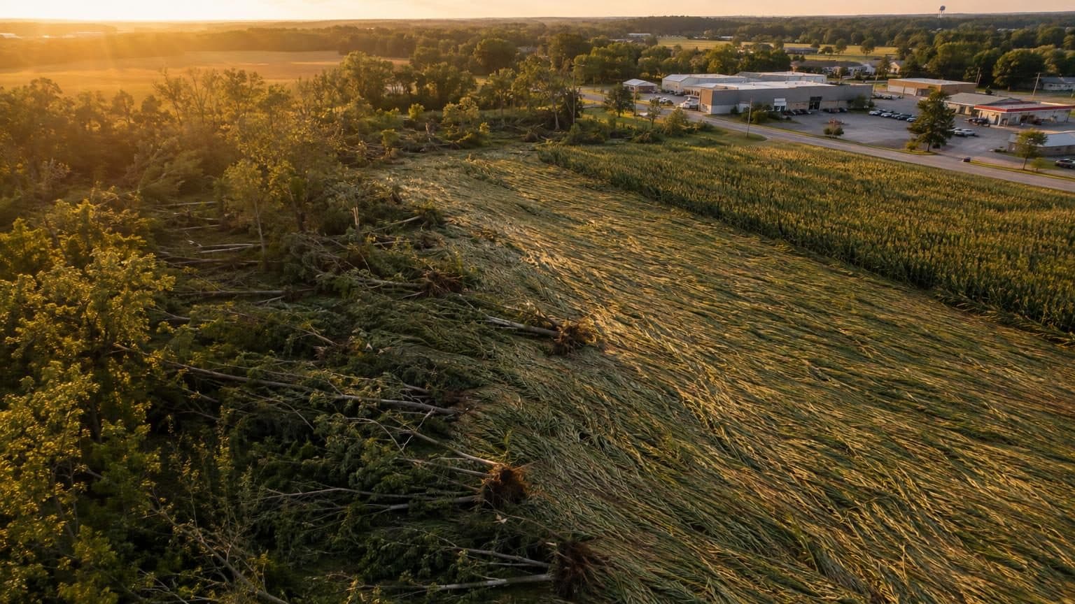
Surveyors walk the damage and read it the way an investigator reads a scene. Uprooted large trees are the best wind vane: their trunks fall in the direction the wind blew. Small branches and snapped trees say less, because they can fail from a weakness in the tree rather than the wind's direction.
- Tornado: trees fall generally pointing inward toward the center of the path, and large uprooted trees often cross each other in a herringbone pattern.10,11
- Tornado: leaf litter, dirt or mud is often sprayed on the sides of objects, and projectiles are stuck in the ground or in nearby objects, though downbursts can throw projectiles too.5
- Straight-line wind: debris is blown downwind in one general direction, often fanning out from an impact point.12,5
- Straight-line wind: from the air, downbursts often leave pockets of damage, like footprints, that may not connect.5
| Clue | Tornado | Downburst (straight-line wind) |
|---|---|---|
| Shape of damage area | Long and thin | Short and wide |
| Damage gradient | High | Low |
| Debris paths | Narrow, convergent | Broad, divergent |
| Look of the damage | Chopped up, chaotic | Laid out neatly |
| On the ground | Swirls, mud spattered on walls | No swirls, no mud |
| From the air | Vortex marks, herringbone tree falls | Starburst pattern from microbursts |
Storm Data's rule: damage counts as a tornado if it could only have been tornadic, or if it shows two of these: well-defined edges to the damage path; trees lying 30 degrees or more off the path's axis; suction vortex marks, ground striations or extreme missiles; or a converging debris pattern. Credible eyewitness reports, photos or video of a violent circulation from cloud base to ground also count, even with little damage.4
Surveyors also check radar, photos, video and eyewitness accounts. Without conclusive evidence of rotation reaching from the ground into the parent storm, the NWS classifies damage as non-tornadic.6
Why the two get mixed up
- Twisted trees: a tree with uneven limbs catches more wind on one side, so straight wind can twist it apart.
- The roar: winds of 75 mph or more often sound very loud, leading some people to believe they heard a tornado.12
- Fast tornadoes: forward speed adds to the winds on one side, so debris can lie in one direction and the convergent pattern may be missing. A 100 mph tornado moving east at 50 mph produces 150 mph winds on its south side and 50 mph on its north side.11,4
- Terrain: hills and valleys can bend downburst debris into a convergent pattern, and wind funneled between them can do much more damage.
- Both at once: rear-flank downdraft winds can hit right next to a tornado, and when the two can be told apart, Storm Data logs that damage as thunderstorm wind, not as part of the tornado path.1,4
One night shows how closely they mix. On July 14, 2024, a line of storms produced 9 tornadoes in the NWS Chicago area and two main corridors of straight-line winds of 70 mph or more.14
In St. Charles, a brief EF0 tornado spun up as a surge of straight-line winds arrived, damaged the roof of a self-storage building and tossed cart corrals at a store; past a shopping center, the damage appeared to change to straight-line wind damage.14
Same damage from either wind on commercial buildings
The EF scale estimates wind from damage to 28 indicators, including strip malls, big box stores, apartments of 3 stories or less, metal buildings and warehouses. Its speeds are 3-second gust estimates at the point of damage, not measurements.9
| Building | Damage | Expected | Range |
|---|---|---|---|
| Strip mall | Roof covering lifted at eaves and corners | 80 | 66 to 100 |
| Strip mall | Roof decking lifted | 101 | 84 to 122 |
| Strip mall | Facade or parapet walls collapsed | 103 | 85 to 125 |
| Apartments, 3 stories or less | Under 20% of roof covering lost | 99 | 82 to 121 |
| Apartments, 3 stories or less | Roof decking lifted; over 20% of roof covering lost | 124 | 107 to 146 |
| Metal building (warehouse, industrial) | Overhead doors collapsed in or out | 89 | 75 to 108 |
Most of those speeds are within reach of straight-line winds: microbursts can top 100 mph, and derecho gusts as high as 130 mph, equal to a strong EF2 tornado, have been recorded.2,8
Storm Data's thunderstorm wind guide says roofs may be partially peeled off industrial, commercial and warehouse buildings at 75 to 89 mph. Damage alone does not automatically mean winds reached 58 mph, though: when estimating thunderstorm winds, Storm Data preparers weigh the damaged property's condition, age, construction, exposure, terrain and nearby objects that funnel wind.4
How each is rated and recorded
Tornadoes are rated on the EF scale, and a tornado's rating is the highest wind estimated anywhere along its path.
| Rating | 3-second gust (mph) |
|---|---|
| EF0 | 65 to 85 |
| EF1 | 86 to 110 |
| EF2 | 111 to 135 |
| EF3 | 136 to 165 |
| EF4 | 166 to 200 |
| EF5 | Over 200 |
A tornado that damages none of the scale's qualified indicators, such as one that crosses only crops, can be rated EF-Unknown (EF-U). An EF rating can be off by one category either way.5,4,14
Storm Data logs downbursts, microbursts, macrobursts and gustnadoes as Thunderstorm Wind events, with the peak wind in knots marked as measured or estimated. Tornado events carry an EF rating instead.1,4
Thunderstorm wind is severe at 58 mph (50 knots), and Storm Data calls damage from winds over 74 mph (64 knots) extreme, equal to EF0-category winds.5,4
Finding the survey for your storm
Not every storm gets a survey. Surveys usually follow significant events: widespread damage, injuries, deaths, heavy media interest, or doubt about the type of storm. Officials and insurance companies use the results, so check these sources for the date and place of your damage.5
- NWS office event pages: for July 14, 2024, NWS Chicago posted a summary of each tornado and straight-line wind corridor, with KMZ and shapefile downloads.14
- Damage Assessment Toolkit: the public viewer at apps.dat.noaa.gov/StormDamage/DamageViewer lets users view, download and analyze survey data for a chosen time range, anywhere in the country.16
- To find a storm in the viewer, set the Begin and End dates in the upper right corner; survey data download as KMZ files.17
- Toolkit data are quality controlled but still preliminary; official statistics are in Storm Data.18
- Storm Prediction Center (SPC) storm reports: preliminary reports listed as is, with each day running from 1200 UTC to 1159 UTC the next day.19
- NCEI Storm Events Database: searchable Storm Data, with tornado and thunderstorm wind events filed by county. Events take 3 months to appear.20
How Cloudbreak helps
Storm monitoring
Our proprietary predictive storm engine, built with AI and backed by meteorologists, watches every building against its own roof-based thresholds; our on-call team picks up urgent matches within 15 minutes, day or night.
Free hail history
Every hail and wind day near any address since 2010, with a free PDF and storm alerts.
Pre-loss documentation
A dated record of every roof section, elevation and rooftop unit, in photos, drone video and notes, with original files and timestamps intact.
Questions
- Was it a tornado or straight-line winds?
- Check whether the local NWS office surveyed the area, then look up the date in the Damage Assessment Toolkit viewer and, about 3 months later, the NCEI Storm Events Database, which lists it as Tornado or Thunderstorm Wind. Surveyors judge from the damage pattern: convergent debris points to a tornado; debris in one direction or fanned out points to straight-line winds.10,5,11,21,4,16,20
- What is the difference between a tornado and straight-line wind damage?
- Wind flows into a tornado, so its damage is narrow, chaotic and convergent. Wind flows out of a downburst, so its damage is wider, laid out neatly and divergent. Straight-line wind damage can be as severe as a weak tornado's.
- Can straight-line winds be as strong as a tornado?
- Yes. NOAA reports microburst winds up to 168 mph and macroburst damage up to EF3, and a derecho produced a measured 128 mph gust in eastern Wisconsin on May 31, 1998.7,3

Cloudbreak
The owner-side property protection team for commercial and multifamily owners in storm country: a dated record of every building, nightly storm checks and a review of your policy, before a loss.
Sources
Written by the Cloudbreak team. Numbers, dates and rules cite the published sources below.
- 1. NOAA National Weather Service, Fort Worth/Dallas: Weather 101: Damage Surveys and the EF-Scale
- 2. NOAA National Severe Storms Laboratory: Severe Weather 101: Damaging Winds Types
- 3. NOAA Storm Prediction Center: Facts About Derechos: Very Damaging Windstorms
- 4. NOAA National Weather Service: NWS Instruction 10-1605: Storm Data Preparation (July 26, 2021)
- 5. NOAA National Weather Service, La Crosse, WI: Severe Local Storm Damage Assessment
- 6. NOAA National Weather Service, Louisville: Thunderstorm Winds Explained
- 7. NOAA JetStream: Thunderstorm Hazards: Damaging Wind
- 8. NOAA Storm Prediction Center: Derechos FAQ
- 9. NOAA Storm Prediction Center: Enhanced Fujita Tornado Damage Scale
- 10. NOAA National Weather Service, Binghamton, NY: How the NWS determines Wind Damage and Tornadoes
- 11. NOAA National Weather Service, Grand Rapids, MI: Storm Damage Survey Training: The Increased Verification of Severe Thunderstorms Program (2007)
- 12. NOAA National Weather Service, Northern Indiana: Straight Line Winds vs. Tornado: What's the Difference?
- 13. NOAA National Weather Service, Shreveport: Streamlining the Tornado Survey Process: NWS Perspective (2021)
- 14. NOAA National Weather Service, Chicago: July 14, 2024: Nighttime Line of Storms Produces Swaths of Wind Damage and Embedded Tornadoes
- 15. Texas Tech University Wind Science and Engineering Center, hosted by NOAA Storm Prediction Center: A Recommendation for an Enhanced Fujita Scale (EF-Scale), June 2004
- 16. NOAA National Weather Service: Service Change Notice 22-84: Operational Implementation of NWS Damage Assessment Toolkit
- 17. NOAA National Weather Service, Chicago: How to Download Survey .KMZ Files from the NWS Damage Assessment Toolkit
- 18. NOAA National Weather Service: NWS Damage Assessment Toolkit: Damage Viewer map service
- 19. NOAA Storm Prediction Center: Severe Weather Summaries
- 20. NOAA National Centers for Environmental Information: Search: Storm Events Database
- 21. NOAA National Severe Storms Laboratory: Severe Weather 101: Damaging Winds FAQ