Hurricane Bob (1985)
Hurricane Bob was a Category 1 hurricane at its peak, with 75 mph winds and a lowest pressure of 1002 mb, per NOAA's National Hurricane Center. Modeled winds reached tropical-storm force (39 mph) at 4 of the cities we track; the strongest was Hilton Head Island, SC, with a modeled peak gust of 63 mph.
- Peak strength75 mph winds (1-minute)
- Category 1
- Cities with tropical-storm-force windsModeled, of the cities we track
- 4
- LandfallsFirst July 25, 1985
- 1
- Lowest pressure
- 1002 mb
Track, wind field and cities
Select a piece of the track or a city for details.
- Depression or weaker
- Tropical storm
- Hurricane, Category 1 or 2
- Major hurricane, Category 3 to 5
- Landfall
- City (larger ring, stronger modeled gust)
- Modeled wind field, 39 to 111 mph sustained (darker, stronger; orange 111 mph+)
The shaded areas are where our model puts Hurricane Bob’s sustained winds over open land at 39 mph or more (tropical-storm force), 58, 74 (hurricane force) and 111 mph (major hurricane force) at some point along its track. Modeled, not measured. How we model hurricane winds
Landfalls
- July 25, 1985, Category 1 at 75 mph, about 14 miles from Hilton Head Island, SC
Modeled winds at cities (4)
Estimated peak winds for open, flat ground at each city’s center. Not measurements. How we model hurricane winds
| City | Peak gust | Sustained | Closest pass | Peak |
|---|---|---|---|---|
| Hilton Head Island, SC | 63 mph | 52 mph | 14 miles | Jul 24, 1985, 9:45 PM EDT |
| Charleston, SC | 62 mph | 50 mph | 40 miles | Jul 25, 1985, 2:00 AM EDT |
| Savannah, GA | 57 mph | 47 mph | 41 miles | Jul 24, 1985, 7:45 PM EDT |
| Palm Bay, FL | 48 mph | 39 mph | 18 miles | Jul 24, 1985, 2:45 AM EDT |
What happened
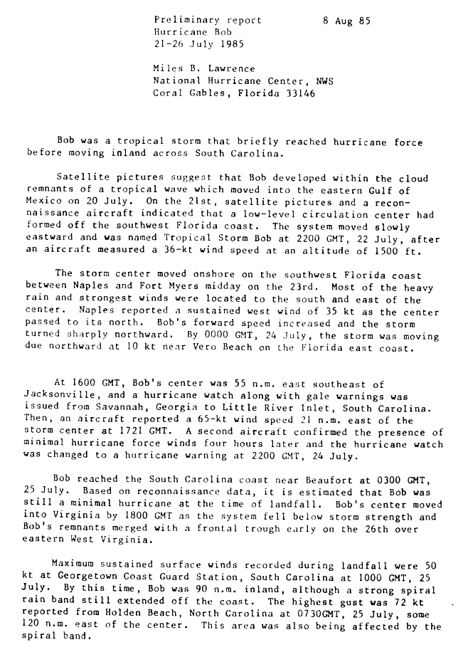
Bob crossed southwest Florida between Naples and Fort Myers as a tropical storm on July 23, 1985.1 It then came ashore on the South Carolina coast near Beaufort, at Fripp Island, at 0300 UTC on July 25 (11 p.m. EDT on July 24) as a minimal Category 1 hurricane with 65-knot (75 mph) winds and a 1003 mb pressure.1,2,3
Rain totaled up to 21.5 inches in 48 hours at Everglades City, Florida, and 6 to 8 inches over parts of the Carolinas.4 Charleston Airport received 5 inches of rain, and gusts reached 44 mph in downtown Charleston and 48 mph at Folly Beach.5 The highest gust NHC reported was 72 knots (83 mph) at Holden Beach, North Carolina.1 The tide at Charleston Harbor peaked at 6.6 feet above mean low water, and NHC estimated the storm surge at 3 to 5 feet above normal.4 NHC attributed one traffic death in North Carolina to Bob and rated the damage as minor.4
Sources
- 1. NOAA National Hurricane Center: Preliminary Report, Hurricane Bob, 21-26 July 1985 (page 1)
- 2. South Carolina State Climatology Office: Hurricanes and Tropical Storms Affecting South Carolina 1980-1989
- 3. NOAA National Hurricane Center: Preliminary Report, Hurricane Bob: Preliminary best track
- 4. NOAA National Hurricane Center: Preliminary Report, Hurricane Bob, 21-26 July 1985 (page 2)
- 5. NWS Charleston, SC: Tropical Cyclone History for Southeast South Carolina and Northern Portions of Southeast Georgia
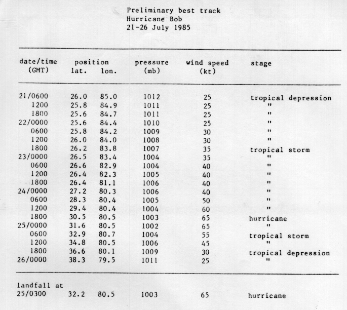

Best track (21 positions)
| Time | Status | Wind | Pressure | Position |
|---|---|---|---|---|
| Jul 21, 06:00 UTC | Tropical depression | 29 mph | 1012 mb | 26.0°N, 85.0°W |
| Jul 21, 12:00 UTC | Tropical depression | 29 mph | 1011 mb | 25.8°N, 84.9°W |
| Jul 21, 18:00 UTC | Tropical depression | 29 mph | 1011 mb | 25.6°N, 84.7°W |
| Jul 22, 00:00 UTC | Tropical depression | 29 mph | 1010 mb | 25.6°N, 84.4°W |
| Jul 22, 06:00 UTC | Tropical depression | 35 mph | 1009 mb | 25.8°N, 84.2°W |
| Jul 22, 12:00 UTC | Tropical depression | 35 mph | 1008 mb | 26.0°N, 84.0°W |
| Jul 22, 18:00 UTC | Tropical storm | 40 mph | 1007 mb | 26.2°N, 83.8°W |
| Jul 23, 00:00 UTC | Tropical storm | 40 mph | 1004 mb | 26.5°N, 83.4°W |
| Jul 23, 06:00 UTC | Tropical storm | 46 mph | 1004 mb | 26.6°N, 82.9°W |
| Jul 23, 12:00 UTC | Tropical storm | 46 mph | 1005 mb | 26.4°N, 82.3°W |
| Jul 23, 18:00 UTC | Tropical storm | 46 mph | 1006 mb | 26.4°N, 81.1°W |
| Jul 24, 00:00 UTC | Tropical storm | 46 mph | 1006 mb | 27.2°N, 80.3°W |