Hurricane Alma (1966)
Hurricane Alma was a Category 3 hurricane at its peak, with 115 mph winds and a lowest pressure of 970 mb, per NOAA's National Hurricane Center. Modeled winds reached tropical-storm force (39 mph) at 9 of the cities we track; the strongest was North Port, FL, with a modeled peak gust of 86 mph.
- Peak strength115 mph winds (1-minute)
- Category 3
- Cities with tropical-storm-force windsModeled, of the cities we track
- 9
- LandfallsFirst June 8, 1966
- 3
- Lowest pressure
- 970 mb
Track, wind field and cities
Select a piece of the track or a city for details.
- Depression or weaker
- Tropical storm
- Hurricane, Category 1 or 2
- Major hurricane, Category 3 to 5
- Landfall
- City (larger ring, stronger modeled gust)
- Modeled wind field, 39 to 111 mph sustained (darker, stronger; orange 111 mph+)
The shaded areas are where our model puts Hurricane Alma’s sustained winds over open land at 39 mph or more (tropical-storm force), 58, 74 (hurricane force) and 111 mph (major hurricane force) at some point along its track. Modeled, not measured. How we model hurricane winds
Landfalls
- June 8, 1966, Category 2 at 98 mph, in Cuba
- June 8, 1966, Category 2 at 104 mph, in Cuba
- June 9, 1966, Category 1 at 86 mph, about 25 miles from Tallahassee, FL
Modeled winds at cities (9)
Estimated peak winds for open, flat ground at each city’s center. Not measurements. How we model hurricane winds
| City | Peak gust | Sustained | Closest pass | Peak |
|---|---|---|---|---|
| North Port, FL | 86 mph | 70 mph | 60 miles | Jun 8, 1966, 11:15 PM GMT-4 |
| Cape Coral, FL | 83 mph | 68 mph | 62 miles | Jun 8, 1966, 9:30 PM GMT-4 |
| Tampa, FL | 82 mph | 67 mph | 65 miles | Jun 9, 1966, 2:00 AM GMT-4 |
| Naples, FL | 81 mph | 66 mph | 63 miles | Jun 8, 1966, 8:00 PM GMT-4 |
| Tallahassee, FL | 80 mph | 65 mph | 15 miles | Jun 9, 1966, 5:00 PM GMT-4 |
| Lakeland, FL | 61 mph | 50 mph | 96 miles | Jun 9, 1966, 1:45 AM GMT-4 |
| Wilmington, NC | 51 mph | 41 mph | 63 miles | Jun 11, 1966, 8:00 AM GMT-4 |
| Gainesville, FL | 50 mph | 41 mph | 101 miles | Jun 9, 1966, 5:00 PM GMT-4 |
| Ocala, FL | 50 mph | 40 mph | 125 miles | Jun 9, 1966, 5:45 AM GMT-4 |
What happened
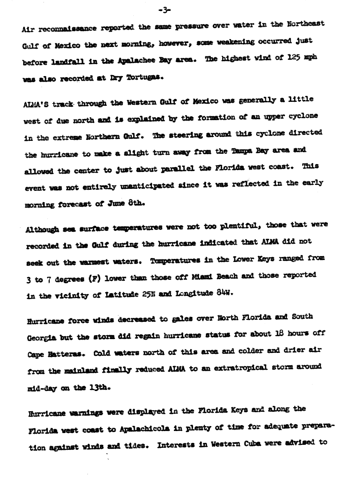
Alma crossed western Cuba, passed between Key West and the Dry Tortugas, and moved north along Florida's Gulf coast to come ashore in the Apalachee Bay area.1,2 NHC's best track puts that landfall at 2100 UTC on June 9, 1966, as a Category 1 hurricane with 75-knot (86 mph) winds and a 977 mb pressure.3
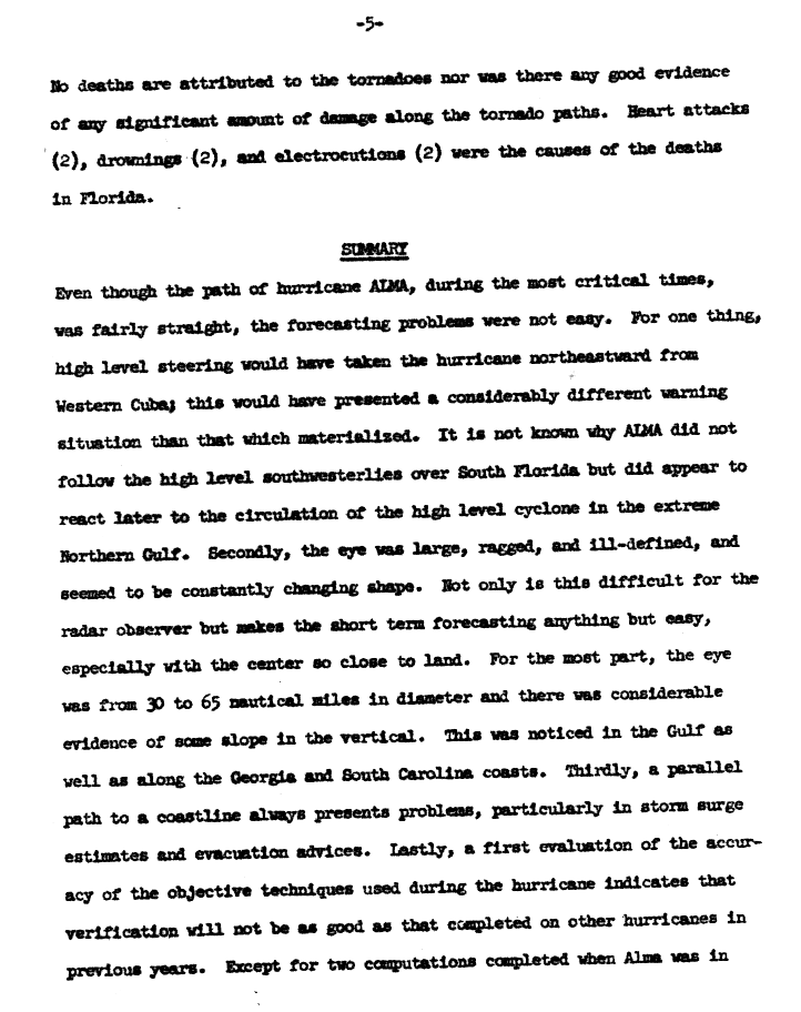
Dry Tortugas recorded Alma's highest wind, 125 mph, and damage in the lower Keys was estimated at about one-third of a million dollars.1,2 Tides on Florida's west coast ran up to 10 feet above normal, highest near New Port Richey, Red Level near Crystal River and Cedar Key, where much of the town flooded.4 The report lists eight tornadoes in Florida, some possibly only waterspouts: two in Miami, three in Sarasota, one in Jacksonville and two in Marianna, with no good evidence of significant damage along their paths.4,5 The Weather Bureau's preliminary report lists 6 deaths and $10 million in damage in Florida and $50,000 in damage in Georgia.4
Sources
- 1. NOAA National Hurricane Center: Alma (a preliminary), June 4 to 13, 1966 (U.S. Weather Bureau), page 2, storm wallet archive
- 2. NOAA National Hurricane Center: Alma (a preliminary), June 4 to 13, 1966 (U.S. Weather Bureau), page 3, storm wallet archive
- 3. NOAA National Hurricane Center: Atlantic hurricane database (HURDAT2), 1851 to 2025
- 4. NOAA National Hurricane Center: Alma (a preliminary), June 4 to 13, 1966 (U.S. Weather Bureau), page 4, storm wallet archive
- 5. NOAA National Hurricane Center: Alma (a preliminary), June 4 to 13, 1966 (U.S. Weather Bureau), page 5, storm wallet archive


Best track (41 positions)
| Time | Status | Wind | Pressure | Position |
|---|---|---|---|---|
| Jun 5, 00:00 UTC | Tropical depression | 29 mph | 16.0°N, 84.7°W | |
| Jun 5, 06:00 UTC | Tropical depression | 29 mph | 16.1°N, 84.8°W | |
| Jun 5, 12:00 UTC | Tropical depression | 35 mph | 1006 mb | 16.3°N, 84.8°W |
| Jun 5, 18:00 UTC | Tropical depression | 35 mph | 16.8°N, 84.7°W | |
| Jun 6, 00:00 UTC | Tropical storm | 40 mph | 17.3°N, 84.6°W | |
| Jun 6, 06:00 UTC | Tropical storm | 46 mph | 1000 mb | 17.6°N, 84.4°W |
| Jun 6, 12:00 UTC | Tropical storm | 58 mph | 996 mb | 18.0°N, 84.2°W |
| Jun 6, 18:00 UTC | Category 1 hurricane | 75 mph | 990 mb | 18.5°N, 84.1°W |
| Jun 7, 00:00 UTC | Category 1 hurricane | 75 mph | 990 mb | 18.8°N, 84.0°W |
| Jun 7, 06:00 UTC | Category 1 hurricane | 75 mph | 986 mb | 19.0°N, 83.9°W |
| Jun 7, 12:00 UTC | Category 1 hurricane | 81 mph | 983 mb | 19.3°N, 83.9°W |
| Jun 7, 18:00 UTC | Category 1 hurricane | 86 mph | 19.6°N, 83.8°W |