Hurricane Betsy (1965)
Hurricane Betsy was a Category 4 hurricane at its peak, with 138 mph winds and a lowest pressure of 942 mb, per NOAA's National Hurricane Center. Modeled winds reached tropical-storm force (39 mph) at 13 of the cities we track; the strongest was New Orleans, LA, with a modeled peak gust of 128 mph.
- Peak strength138 mph winds (1-minute)
- Category 4
- Cities with tropical-storm-force windsModeled, of the cities we track
- 13
- LandfallsFirst August 29, 1965
- 5
- Lowest pressure
- 942 mb
Track, wind field and cities
Select a piece of the track or a city for details.
- Depression or weaker
- Tropical storm
- Hurricane, Category 1 or 2
- Major hurricane, Category 3 to 5
- Landfall
- City (larger ring, stronger modeled gust)
- Modeled wind field, 39 to 111 mph sustained (darker, stronger; orange 111 mph+)
The shaded areas are where our model puts Hurricane Betsy’s sustained winds over open land at 39 mph or more (tropical-storm force), 58, 74 (hurricane force) and 111 mph (major hurricane force) at some point along its track. Modeled, not measured. How we model hurricane winds
Landfalls
- August 29, 1965, tropical storm at 40 mph, in Saint-Barthélemy
- August 29, 1965, tropical storm at 40 mph, in Anguilla
- September 7, 1965, Category 3 at 121 mph, in the Bahamas
- September 8, 1965, Category 3 at 115 mph, about 57 miles from Miami, FL
- September 10, 1965, Category 4 at 132 mph, about 60 miles from New Orleans, LA
Modeled winds at cities (13)
Estimated peak winds for open, flat ground at each city’s center. Not measurements. How we model hurricane winds
| City | Peak gust | Sustained | Closest pass | Peak |
|---|---|---|---|---|
| New Orleans, LA | 128 mph | 104 mph | 50 miles | Sep 9, 1965, 11:00 PM GMT-5 |
| Miami, FL | 114 mph | 93 mph | 51 miles | Sep 8, 1965, 5:30 AM GMT-4 |
| Slidell, LA | 112 mph | 91 mph | 68 miles | Sep 9, 1965, 11:00 PM GMT-5 |
| Baton Rouge, LA | 96 mph | 78 mph | 14 miles | Sep 10, 1965, 3:15 AM GMT-5 |
| Gulfport, MS | 92 mph | 75 mph | 104 miles | Sep 9, 1965, 11:00 PM GMT-5 |
| Naples, FL | 80 mph | 65 mph | 67 miles | Sep 8, 1965, 2:00 PM GMT-4 |
| Lafayette, LA | 68 mph | 55 mph | 37 miles | Sep 10, 1965, 12:45 AM GMT-5 |
| Mobile, AL | 64 mph | 52 mph | 156 miles | Sep 9, 1965, 10:30 PM GMT-5 |
| Daphne, AL | 61 mph | 49 mph | 164 miles | Sep 9, 1965, 10:00 PM GMT-5 |
| Cape Coral, FL | 59 mph | 48 mph | 98 miles | Sep 8, 1965, 3:15 PM GMT-4 |
| Port St. Lucie, FL | 53 mph | 43 mph | 156 miles | Sep 8, 1965, 7:00 AM GMT-4 |
| Pensacola, FL | 53 mph | 43 mph | 185 miles | Sep 9, 1965, 9:00 PM GMT-4 |
| North Port, FL | 48 mph | 39 mph | 123 miles | Sep 8, 1965, 7:45 AM GMT-4 |
What happened
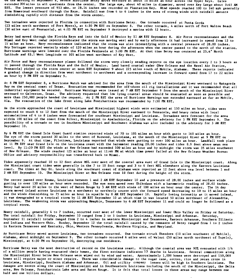
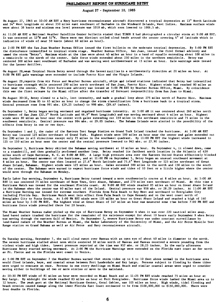
After crossing the Bahamas, Betsy came ashore in the upper Florida Keys near Key Largo at 1100 UTC on September 8, 1965, as a Category 3 hurricane with 100-knot (115 mph) winds, according to NHC's best track.1,2,3 It made a second landfall near Grand Isle, Louisiana, at 0400 UTC on September 10 as a Category 4 hurricane with 115-knot (132 mph) winds and a 946 mb pressure.1,2
Winds of 100 to 140 mph hit from Homestead south through the Keys, and the National Hurricane Center in Coral Gables measured a 105 mph peak gust.2,3 The Weather Bureau's preliminary report estimated $100 million to $150 million in damage along the lower Florida east coast from wind, tidal flooding and beach erosion, and four deaths in Florida.3
In Louisiana, the Grand Isle Coast Guard station reported gusts to 160 mph, Houma reported gusts over 130 mph, and New Orleans winds reached 125 mph before the city's Weather Bureau office lost power.2 The report estimates tides of 10 to 12 feet above mean sea level over most of the coast from east of Grand Isle to the Mississippi coast, with 8.9 feet near Grand Isle at landfall and 7 to 10 feet along the Mississippi coast, and the Mississippi River at New Orleans rose 10 feet.2 Wind and water destroyed several communities along the Mississippi River below New Orleans, about 1,000 homes were destroyed, and the report estimated 150,000 more would need major or minor repairs.2 NHC lists 75 US deaths and $1.42 billion in US damage in 1965 dollars.4
Sources
- 1. NOAA National Hurricane Center: Atlantic hurricane database (HURDAT2), 1851 to 2025
- 2. NOAA National Hurricane Center: Preliminary Report on Hurricane Betsy, August 27 to September 10, 1965 (U.S. Weather Bureau), page 7, storm wallet archive
- 3. NOAA National Hurricane Center: Preliminary Report on Hurricane Betsy, August 27 to September 10, 1965 (U.S. Weather Bureau), page 6, storm wallet archive
- 4. NOAA National Hurricane Center: The Deadliest, Costliest, and Most Intense United States Tropical Cyclones from 1851 to 2010 (NOAA Technical Memorandum NWS NHC-6)
Best track (74 positions)
| Time | Status | Wind | Pressure | Position |
|---|---|---|---|---|
| Aug 27, 00:00 UTC | Tropical depression | 29 mph | 11.0°N, 50.5°W | |
| Aug 27, 06:00 UTC | Tropical depression | 35 mph | 11.2°N, 51.8°W | |
| Aug 27, 12:00 UTC | Tropical depression | 35 mph | 11.4°N, 53.1°W | |
| Aug 27, 18:00 UTC | Tropical depression | 35 mph | 1007 mb | 11.7°N, 54.5°W |
| Aug 28, 00:00 UTC | Tropical depression | 35 mph | 12.1°N, 56.1°W | |
| Aug 28, 06:00 UTC | Tropical depression | 35 mph | 12.8°N, 57.9°W | |
| Aug 28, 12:00 UTC | Tropical depression | 35 mph | 1010 mb | 14.0°N, 59.8°W |
| Aug 28, 18:00 UTC | Tropical depression | 35 mph | 15.1°N, 61.1°W | |
| Aug 29, 00:00 UTC | Tropical depression | 35 mph | 1010 mb | 16.2°N, 62.0°W |
| Aug 29, 06:00 UTC | Tropical storm | 40 mph | 17.6°N, 62.7°W | |
| Aug 29, 08:00 UTC (landfall) | Tropical storm | 40 mph | 17.9°N, 62.9°W | |
| Aug 29, 09:00 UTC (landfall) | Tropical storm | 40 mph | 18.2°N, 63.0°W |