Hurricane Dora (1964)
Hurricane Dora was a Category 4 hurricane at its peak, with 132 mph winds and a lowest pressure of 942 mb, per NOAA's National Hurricane Center. Modeled winds reached tropical-storm force (39 mph) at 11 of the cities we track; the strongest was Jacksonville, FL, with a modeled peak gust of 76 mph.
- Peak strength132 mph winds (1-minute)
- Category 4
- Cities with tropical-storm-force windsModeled, of the cities we track
- 11
- LandfallsFirst September 10, 1964
- 1
- Lowest pressure
- 942 mb
Track, wind field and cities
Select a piece of the track or a city for details.
- Depression or weaker
- Tropical storm
- Hurricane, Category 1 or 2
- Major hurricane, Category 3 to 5
- Landfall
- City (larger ring, stronger modeled gust)
- Modeled wind field, 39 to 111 mph sustained (darker, stronger; orange 111 mph+)
The shaded areas are where our model puts Hurricane Dora’s sustained winds over open land at 39 mph or more (tropical-storm force), 58, 74 (hurricane force) and 111 mph (major hurricane force) at some point along its track. Modeled, not measured. How we model hurricane winds
Landfalls
- September 10, 1964, Category 2 at 109 mph, about 37 miles from Jacksonville, FL
Modeled winds at cities (11)
Estimated peak winds for open, flat ground at each city’s center. Not measurements. How we model hurricane winds
| City | Peak gust | Sustained | Closest pass | Peak |
|---|---|---|---|---|
| Jacksonville, FL | 76 mph | 62 mph | 27 miles | Sep 9, 1964, 7:45 PM GMT-4 |
| Deltona, FL | 74 mph | 60 mph | 67 miles | Sep 9, 1964, 7:45 PM GMT-4 |
| Savannah, GA | 70 mph | 57 mph | 36 miles | Sep 12, 1964, 11:45 PM GMT-4 |
| Hilton Head Island, SC | 70 mph | 57 mph | 38 miles | Sep 13, 1964, 1:45 AM GMT-4 |
| Gainesville, FL | 67 mph | 55 mph | 22 miles | Sep 10, 1964, 8:00 AM GMT-4 |
| Charleston, SC | 67 mph | 54 mph | 23 miles | Sep 13, 1964, 4:00 AM GMT-4 |
| Myrtle Beach, SC | 59 mph | 48 mph | 4 miles | Sep 13, 1964, 7:15 AM GMT-4 |
| Wilmington, NC | 58 mph | 47 mph | 4 miles | Sep 13, 1964, 10:15 AM GMT-4 |
| Ocala, FL | 57 mph | 47 mph | 57 miles | Sep 10, 1964, 8:00 AM GMT-4 |
| Orlando, FL | 57 mph | 46 mph | 98 miles | Sep 9, 1964, 7:45 PM GMT-4 |
| Tallahassee, FL | 52 mph | 42 mph | 8 miles | Sep 10, 1964, 11:00 PM GMT-4 |
What happened
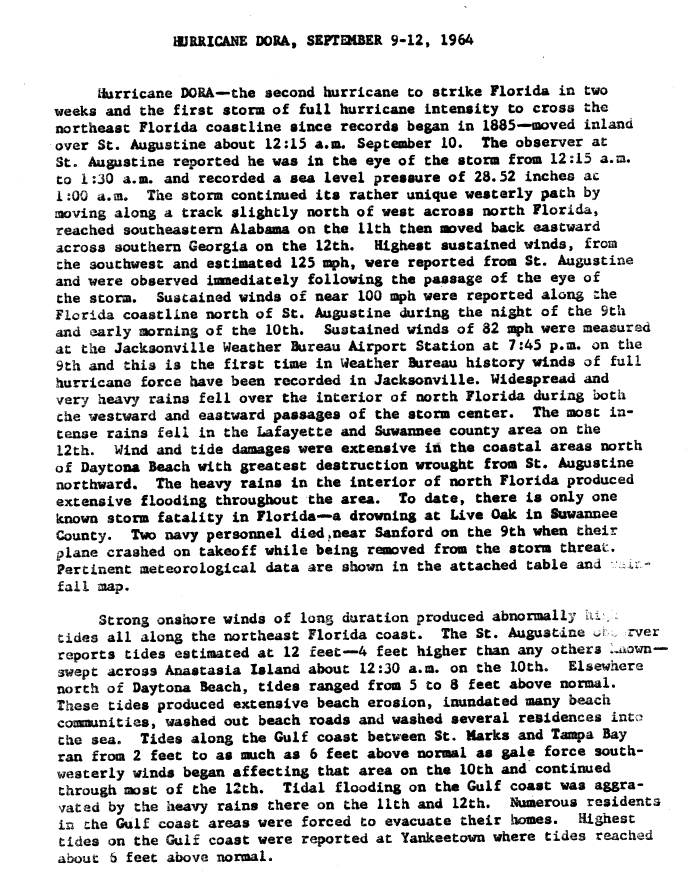
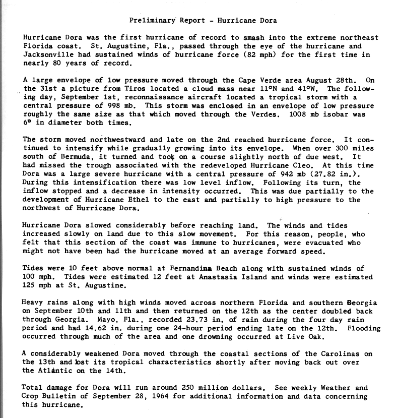
Dora came in from the Atlantic and moved inland over St. Augustine, Florida, at about 12:15 a.m. on September 10, 1964.1 NHC's best track puts the landfall at 0600 UTC that day as a Category 2 hurricane with 95-knot (109 mph) winds and a central pressure of 966 mb.2 The Jacksonville Weather Bureau airport station measured sustained winds of 82 mph, Mayport had a 101 mph gust, and winds at St. Augustine were estimated at 125 mph.1,3
Tides were estimated at 12 feet on Anastasia Island and reached 10 feet above normal at Fernandina Beach.4 The surge flooded many beach communities, washed out beach roads and carried several homes into the sea, and NWS counts over 40 homes lost along the coast.1,5 Structural damage to buildings was limited to coastal areas and to older frame buildings a short way inland.6 In Jacksonville, wind drove the St. Johns River over its north bank and forced residents to evacuate.6
More than 10 inches of rain fell over about 10,000 square miles of north Florida, with 23.73 inches at Mayo and 18.62 inches at Live Oak, which flooded heavily.5 Floodwater entered homes in poorly drained areas, and many roads stayed closed for days.6 NWS estimates Florida damage at $200 to $230 million and reports one drowning death, in Live Oak.5
Sources
- 1. U.S. Weather Bureau (NOAA National Hurricane Center archive): Hurricane Dora, September 9-12, 1964: Preliminary Report, page 1
- 2. NOAA National Hurricane Center: Atlantic hurricane database (HURDAT2), 1851-2025
- 3. U.S. Weather Bureau (NOAA National Hurricane Center archive): Preliminary Report on Hurricane Dora: station data table
- 4. U.S. Weather Bureau (NOAA National Hurricane Center archive): Preliminary Report: Hurricane Dora
- 5. National Weather Service: Flooding in Florida: Hurricane Dora 1964
- 6. U.S. Weather Bureau (NOAA National Hurricane Center archive): Hurricane Dora, September 9-12, 1964: Preliminary Report, page 2


Best track (75 positions)
| Time | Status | Wind | Pressure | Position |
|---|---|---|---|---|
| Aug 28, 12:00 UTC | Tropical depression | 35 mph | 14.0°N, 17.0°W | |
| Aug 28, 18:00 UTC | Tropical depression | 35 mph | 14.0°N, 18.8°W | |
| Aug 29, 00:00 UTC | Tropical depression | 35 mph | 13.9°N, 20.6°W | |
| Aug 29, 06:00 UTC | Tropical depression | 35 mph | 13.7°N, 22.4°W | |
| Aug 29, 12:00 UTC | Tropical depression | 35 mph | 1007 mb | 13.5°N, 24.2°W |
| Aug 29, 18:00 UTC | Tropical depression | 35 mph | 13.3°N, 26.1°W | |
| Aug 30, 00:00 UTC | Tropical depression | 35 mph | 13.0°N, 28.1°W | |
| Aug 30, 06:00 UTC | Tropical depression | 35 mph | 12.7°N, 30.1°W | |
| Aug 30, 12:00 UTC | Tropical depression | 35 mph | 12.4°N, 32.0°W | |
| Aug 30, 18:00 UTC | Tropical depression | 35 mph | 12.0°N, 34.0°W | |
| Aug 31, 00:00 UTC | Tropical depression | 35 mph | 11.6°N, 36.0°W | |
| Aug 31, 06:00 UTC | Tropical depression | 35 mph | 11.2°N, 38.0°W |