Hurricane Debra (1959)
Hurricane Debra was a Category 1 hurricane at its peak, with 86 mph winds and a lowest pressure of 980 mb, per NOAA's National Hurricane Center. Modeled winds reached tropical-storm force (39 mph) at 7 of the cities we track; the strongest was Pasadena, TX, with a modeled peak gust of 88 mph.
- Peak strength86 mph winds (1-minute)
- Category 1
- Cities with tropical-storm-force windsModeled, of the cities we track
- 7
- LandfallsFirst July 25, 1959
- 1
- Lowest pressure
- 980 mb
Track, wind field and cities
Select a piece of the track or a city for details.
- Depression or weaker
- Tropical storm
- Hurricane, Category 1 or 2
- Major hurricane, Category 3 to 5
- Landfall
- City (larger ring, stronger modeled gust)
- Modeled wind field, 39 to 111 mph sustained (darker, stronger; orange 111 mph+)
The shaded areas are where our model puts Hurricane Debra’s sustained winds over open land at 39 mph or more (tropical-storm force), 58, 74 (hurricane force) and 111 mph (major hurricane force) at some point along its track. Modeled, not measured. How we model hurricane winds
Landfalls
- July 25, 1959, Category 1 at 86 mph, about 28 miles from League City, TX
Modeled winds at cities (7)
Estimated peak winds for open, flat ground at each city’s center. Not measurements. How we model hurricane winds
| City | Peak gust | Sustained | Closest pass | Peak |
|---|---|---|---|---|
| Pasadena, TX | 88 mph | 71 mph | 3 miles | Jul 25, 1959, 1:00 AM GMT-5 |
| League City, TX | 87 mph | 71 mph | 0 miles | Jul 25, 1959, 12:45 AM GMT-5 |
| Pearland, TX | 86 mph | 70 mph | 13 miles | Jul 25, 1959, 1:00 AM GMT-5 |
| Sugar Land, TX | 84 mph | 68 mph | 32 miles | Jul 25, 1959, 1:00 AM GMT-5 |
| Houston, TX | 82 mph | 67 mph | 17 miles | Jul 25, 1959, 1:00 AM GMT-5 |
| Conroe, TX | 59 mph | 48 mph | 23 miles | Jul 25, 1959, 1:00 AM GMT-5 |
| Beaumont, TX | 56 mph | 46 mph | 57 miles | Jul 25, 1959, 1:00 AM GMT-5 |
What happened
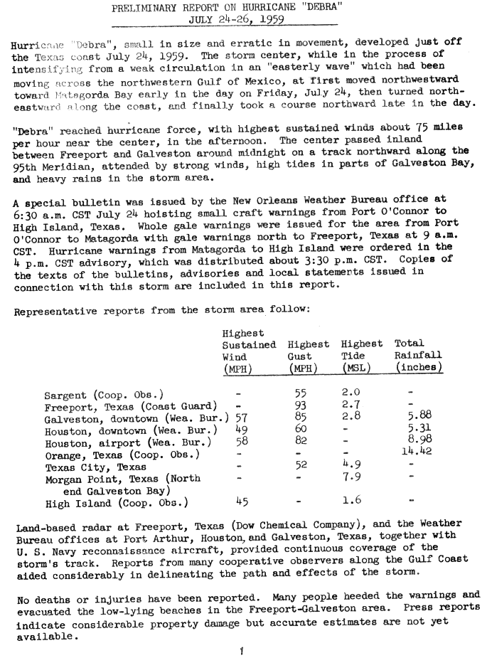
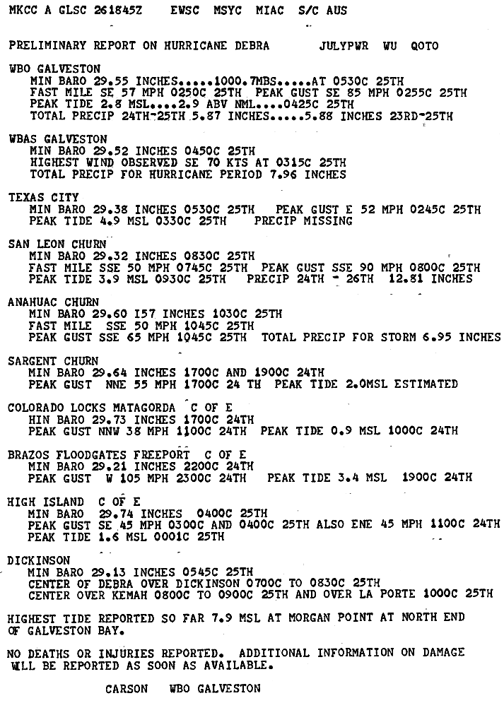
Debra, which formed in the northwestern Gulf of Mexico, made landfall between Freeport and Galveston around 11 p.m. CST on July 24, 1959, as a hurricane with sustained winds of 75 knots (85 mph) and a central pressure of 980 mb.1,2 The center then moved north over Dickinson, Kemah and La Porte on the morning of July 25 and passed over the Houston area as a strong tropical storm.2,3
The highest measured gust was 105 mph at the Brazos River floodgates near Freeport.2,3 Gusts reached 90 mph at San Leon, 85 mph at the Galveston Weather Bureau office and 82 mph at Houston's airport.1,3 Storm tides ran 2 to 7 feet above mean sea level on Bolivar Peninsula and around Galveston Bay, peaking at 7.9 feet at Morgan Point at the north end of the bay and 4.9 feet at Texas City.2,3 The Houston Weather Bureau reported relatively small damage in metro Houston, mostly downed power lines and trees.4 No deaths or injuries were reported.1
Sources
- 1. U.S. Weather Bureau, NOAA National Hurricane Center archive: Preliminary Report on Hurricane "Debra", July 24-26, 1959
- 2. NWS Lake Charles: Hurricane Debra (July 22-27, 1959)
- 3. U.S. Weather Bureau, NOAA National Hurricane Center archive: Preliminary Report on Hurricane Debra, Weather Bureau Office Galveston
- 4. U.S. Weather Bureau, NOAA National Hurricane Center archive: Preliminary Report Hurricane Debra, Weather Bureau Office Houston

Best track (22 positions)
| Time | Status | Wind | Pressure | Position |
|---|---|---|---|---|
| Jul 22, 18:00 UTC | Tropical depression | 29 mph | 27.5°N, 91.2°W | |
| Jul 23, 00:00 UTC | Tropical depression | 29 mph | 27.6°N, 91.7°W | |
| Jul 23, 06:00 UTC | Tropical depression | 35 mph | 27.9°N, 92.3°W | |
| Jul 23, 12:00 UTC | Tropical depression | 35 mph | 28.2°N, 92.9°W | |
| Jul 23, 18:00 UTC | Tropical depression | 35 mph | 28.5°N, 93.5°W | |
| Jul 24, 00:00 UTC | Tropical storm | 40 mph | 28.5°N, 94.1°W | |
| Jul 24, 06:00 UTC | Tropical storm | 58 mph | 28.3°N, 94.6°W | |
| Jul 24, 12:00 UTC | Category 1 hurricane | 75 mph | 28.3°N, 95.0°W | |
| Jul 24, 18:00 UTC | Category 1 hurricane | 75 mph | 985 mb | 28.4°N, 95.2°W |
| Jul 25, 00:00 UTC | Category 1 hurricane | 81 mph | 984 mb | 28.7°N, 95.2°W |
| Jul 25, 05:00 UTC (landfall) | Category 1 hurricane | 86 mph | 980 mb | 29.1°N, 95.2°W |
| Jul 25, 06:00 UTC | Category 1 hurricane | 86 mph | 980 mb | 29.2°N, 95.2°W |